


la mure-croix fayollat - font giron

maupassant38
Utilisateur
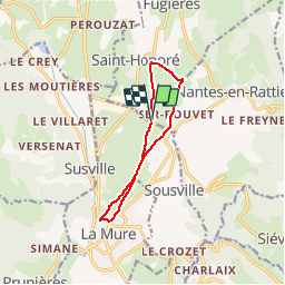

Longueur
9,5 km

Altitude max
976 m

Dénivelé positif
182 m
Km-Effort
11,9 km

Altitude min
871 m

Dénivelé négatif
185 m
Boucle
Oui
Date de création :
2019-02-22 22:31:34.852
Dernière modification :
2019-02-22 22:31:34.859
2h33
Difficulté : Facile

Application GPS de randonnée GRATUITE
 SityTrail
IGN / Instituts géographiques
SityTrail Plus
Le monde est à vous
À propos
Randonnée Marche de 9,5 km à découvrir à Auvergne-Rhône-Alpes, Isère, La Mure. Cette randonnée est proposée par maupassant38.
Localisation
Pays :
France
Région :
Auvergne-Rhône-Alpes
Département/Province :
Isère
Commune :
La Mure
Localité :
Unknown
Départ:(Dec)
Départ:(UTM)
721021 ; 4978817 (31T) N.
Commentaires